Imagine managing a fleet of vehicles without knowing their exact locations or movements. Nowadays, ensuring the safety and efficiency of fleet operations is essential. This is where geofencing comes into play—a technology that creates virtual boundaries to monitor and manage vehicles in real-time. By integrating geofencing into fleet management, businesses can enhance visibility, improve safety, and optimize operations.
What is a Geofence?
A geofence is a virtual perimeter defined around a real-world geographic area. Using technologies like GPS, RFID, Wi-Fi, or cellular data, geofencing allows software applications to trigger predetermined actions when a device enters or exits the defined boundaries. These actions can range from sending alerts to initiating specific processes, making geofencing a versatile tool in various industries.
How Does Geofencing Technology Work?
Geofencing technology operates by utilizing location-based services to define virtual boundaries. Here’s a simplified breakdown:
- Define the Boundary: Using mapping software, a user sets up a virtual boundary around a specific location.
- Monitor Devices: Devices equipped with location-tracking capabilities (like smartphones or GPS trackers) are monitored to detect when they cross these boundaries.
- Trigger Actions: When a device enters or exits the geofenced area, the system triggers predefined actions, such as sending notifications, logging entry/exit times, or initiating security protocols.
This seamless integration of location data and automated responses makes geofencing a powerful tool for real-time monitoring and management.
What is the Purpose of Geofencing?
Geofencing serves multiple purposes across different sectors:
- Security: Monitor and control access to restricted areas.
- Marketing: Send location-based promotions to potential customers.
- Fleet Management: Track vehicle movements, ensure route adherence, and prevent unauthorized usage.
- Time Management: Automatically log employee work hours based on location entries and exits.
By providing real-time data and automated responses, geofencing enhances operational efficiency and security.
Who is Geofencing For?
Geofencing is beneficial for a wide range of users:
- Businesses: Retailers, marketers, and service providers use geofencing for targeted advertising and customer engagement.
- Fleet Managers: Monitor vehicle locations, ensure compliance with routes, and enhance driver accountability.
- Security Agencies: Control access to sensitive areas and monitor unauthorized entries.
- Parents and Guardians: Track children’s movements for safety purposes.
The versatility of geofencing makes it applicable across various industries and personal use cases.
How Does Geofencing Relate to GPS Fleet Management Software?
In fleet management, geofencing integrates seamlessly with GPS tracking systems to provide enhanced oversight:
- Real-Time Monitoring: Track vehicle locations and movements within defined boundaries.
- Route Compliance: Ensure drivers adhere to planned routes, reducing unauthorized route changes.
- Automated Alerts: Receive instant notifications when vehicles enter or exit specific zones, aiding in prompt decision-making.
By combining geofencing with GPS fleet management software, businesses can achieve greater control over their operations, leading to improved efficiency and safety.
3 Ways to Utilize Location-Based Targeting
Location-based targeting uses geofencing to deliver personalized experiences:
- Geo-Targeting: Deliver content or advertisements to users based on their geographic location, enhancing relevance and engagement.
- Beaconing: Use Bluetooth beacons to send messages or notifications to nearby devices, often used in retail environments for promotions.
- Geo-Fencing: Set virtual boundaries to trigger specific actions when a device enters or exits the area, useful for security and operational efficiency.
These methods enable businesses to connect with their audience in meaningful and relevant ways.
Benefits of Using a Geofencing System in Your Fleet
Implementing geofencing in fleet management offers numerous advantages:
Better Targeting
Geofencing allows for precise monitoring of vehicle locations, ensuring that resources are allocated efficiently and routes are optimized for performance.
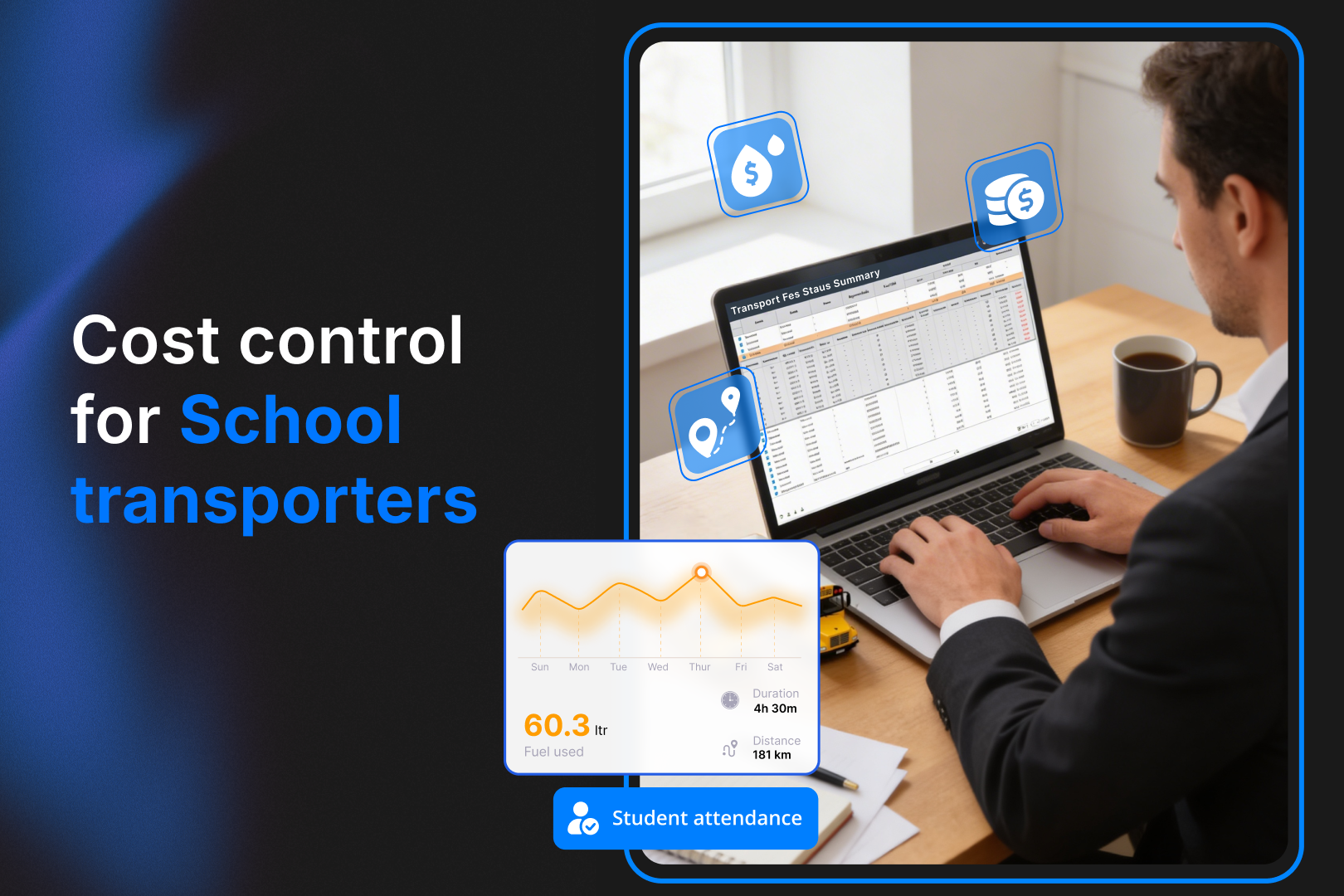
Spend Effectiveness
By monitoring vehicle movements and ensuring adherence to planned routes, businesses can reduce fuel consumption and maintenance costs, leading to significant savings.
Improved Data Collection
Geofencing systems collect valuable data on vehicle usage, driver behavior, and route efficiency, enabling informed decision-making and strategic planning.
Personalized Customer Experience
Timely deliveries and accurate ETAs enhance customer satisfaction. Geofencing ensures that services are provided promptly and reliably.
Competitive Advantage
Businesses that use geofencing can offer superior services, respond swiftly to operational issues, and maintain higher levels of customer trust, setting them apart from competitors.
SmartBus and the Power of Geofencing
One of the most practical applications of geofencing in schools today comes through platforms like SmartBus. It is an AI-powered transportation safety platform that transforms how schools and fleet managers monitor their vehicles.
What is SmartBus?
SmartBus is a complete fleet management system designed for educational institutions and fleet operators. It combines real-time GPS tracking, in-bus video surveillance, driver behavior analytics, and geofencing technology to ensure every ride is secure, efficient, and transparent.
Read More: School Bus Tracking Apps: Top Features Every Parent & School Needs
How Does SmartBus Use Geofencing?
SmartBus utilizes geofencing in several smart ways:
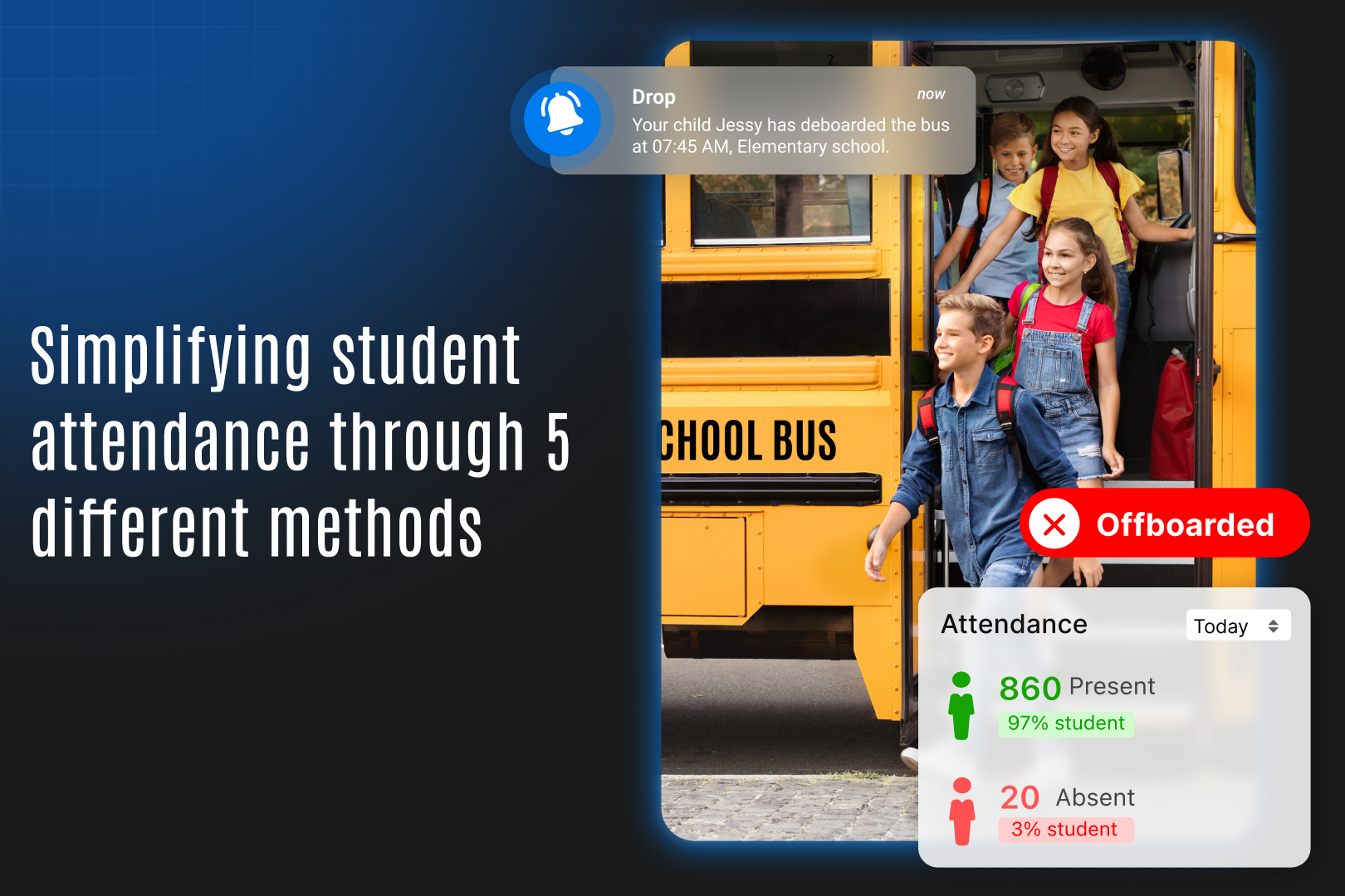
Safe Zone Alerts: Schools and fleet managers can set geofenced “safe zones” such as school premises, residential pick-up points, and bus depots. When a bus enters or leaves these zones, automatic alerts are triggered to notify users in real-time.
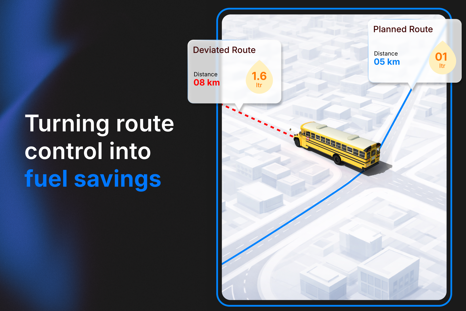
Unauthorized Movement Detection: If a bus moves outside its assigned route or enters a restricted area, the system immediately alerts the concerned authorities. This prevents misuse of school or company vehicles.
Accurate Pick-up and Drop-off Logs: Geofencing allows SmartBus to automatically log when and where students are picked up or dropped off, eliminating manual recordkeeping and increasing accuracy.
Improved Route Planning and Safety Audits: By collecting location data over time, SmartBus helps institutions evaluate route efficiency and identify risk-prone areas, leading to more informed safety decisions.
Parental Peace of Mind: Parents receive notifications the moment their child’s bus enters or exits key geofenced zones, ensuring constant awareness of their child’s location.
Why SmartBus Makes Geofencing More Powerful?
SmartBus doesn’t just use geofencing as a standalone feature. It integrates it with AI-driven analytics, CCTV, and cloud-based dashboards. This interconnected system creates a 360-degree view of fleet activity, making it one of the most reliable safety and visibility software available for student transportation today.
Conclusion
Geofencing stands as a transformative technology in fleet management, offering real-time insights, enhanced security, and operational efficiency. By integrating geofencing into GPS fleet management systems, businesses can monitor vehicle movements, ensure compliance, and deliver superior services. As industries continue to evolve, embracing geofencing will be pivotal in maintaining competitiveness and achieving operational excellence.
FAQs
1. What is geofencing in fleet management?
Geofencing is a technology that uses GPS or other location data to create virtual boundaries around specific areas. When a vehicle enters or exits these zones, alerts and actions are triggered, helping fleet managers monitor and control vehicle movements in real-time.
2. How does geofencing improve fleet safety and visibility?
Geofencing improves safety by detecting unauthorized vehicle movements, ensuring drivers stick to safe, approved routes, and logging activity for audits. It enhances visibility by providing real-time updates on where vehicles are and when they enter or leave designated areas.
3. What are some benefits of using SmartBus with geofencing technology?
SmartBus combines geofencing with AI, video surveillance, and driver behavior monitoring to offer a comprehensive safety solution. It provides real-time alerts, accurate pick-up and drop-off tracking, and ensures students are transported securely, with full oversight for schools and parents.
4. Can geofencing be customized for different business needs?
Yes, geofencing can be used to set different zones such as delivery areas, restricted zones, or school boundaries. Each zone can trigger specific actions like alerts, automated messages, or route validations, making it adaptable for various industries.
5. How do parents benefit from geofencing in school transport systems like SmartBus?
Parents receive instant notifications when the school bus enters or exits geofenced areas like their neighborhood or school, ensuring they are always informed about their child’s commute. It adds a layer of safety and trust in the transportation system.